 |
 |
 |
|
Heritage Sites
Bunce Island (1948) BUNCE ISLAND (1948) In 1664, Holland and Great Britain were at war and the famous Dutch Admiral, De Ruyter, sailed to West Africa to destroy British settlements. He re-captured Goree and proceeded to the Sierra Leone River. He sailed up the river and destroyed the Tassoh and Bunce forts and factories. It was during this visit that he engraved his name on the stone now termed the “De Ruyter Stone”, at King Jimmy Wharf. In 1792 the Royal African Company rebuilt the fort and factory at Bunce Island. The principal articles of trade at this time being elephant tusks, beeswax, cow-hides, gold and “Negroes”. Hostile war ships, pirates and local “war-boy”, often attacked the fort. This happened, for example, in 1695, 1704,1728 and in 1799. The Abolition of the Slave Trade in 1807, however, ended profitable commerce for the island. Substantial and impressive remains of the buildings still stand today, and the whole layout can be seen with walls and bastions. Many cannons still lye in their original positions. The main residential block, stores, powder magazine and slave quarters are also partially intact. When it was proclaimed a National Monument in 1948, Bunce Island started to attract visitors. Museum excursions were made to the island every second Sunday during the dry season up till the eighties, when sea craft was more readily available.
HEDDLE’S FARM (1948)
THE DE RUYTER STONE (1948) In 1664, during the Anglo-Dutch War, the famous Dutch Admiral De Ruyter sailed to Sierra Leone in order to destroy British settlements. He sacked Bunce Island and Tasso Island. He watered at King Jimmy and triumphantly recorded his visit by having his name and that of his second in command inscribed on a rock beside the clear brook, Peter’s Brook. The inscription on the syenite stone reads as follows: “M.A. Ruyter. I. C. Mellon, Vice Admiralen, West Fries, Vant A.D. 1664” After inspection in 1923, the stone was reburied as protection against vandalism and weathering. It has since then been uncovered every ten years (1948, 1958, 1968, 1978 and 1987) for inspection and re-buried waiting the time when finances will be available to erect a permanent building over it which will allow viewing as well as protection.
THE BASTIONS OF FORT THORNTON (1949)
THE REMAINS OF THE EARTH WORKS AND LIVE STOCKADE AT MASAKPAIDU (1949) The village was at the point where the Rivers Bafi and Bagwa unite to form the Sewa River, and was situated on a flat piece of raised ground. 12-foot stakes of the Cotton Tree enclosed the fortified area. Some of these tree stakes took root and the stumps remain till today. Outside the row of stakes was a ditch about 300 yards long. The depth of the ditch is now 6 feet below ground level on the inner side, and the distance to the top ramp of the outer wall is 9 feet; the width is about 12 feet. The ditch must have filled up with time, and is believed to have been much deeper. There were originally two entrances to the stockade, with poles place across the entrance to form a bridge. These were taken up at night or when an attack was expected. The village was finally abandoned when the Sofas under Alimamy sacked it around 1893.
THE GATEWAY TO THE OLD KINGS YARD (1949) Rescued slaves were landed at King Jimmy Wharf and taken to a compound, in which they were temporarily housed. This became known as the King’s Yard, and through this passed the immediate ancestors of nearly all the present day Creoles. These were called the Liberated Africans, as distinct from the Nova Scotians, the Maroons and later the people from the then Protectorate. Some famous people like Samuel Adjai Crowther, the first African Bishop (1862-91) of the Anglican Community and John Ezzidio, the first African elected member of the Legislative council, passed through the King’s Yard as boys. The gateway to the Kings Yard, now leading to a part of the Connaught Hospital, is an impressive piece of architecture with an inscription recording its purpose on a slab over the arch, dated 1819. The inscription reads: “Royal Asylum and Hospital for Africans rescued from slavery by British Valour and Philanthropy”. With the abolition of the Slave Trade and the closing down of the Court of Mixed Commission around 1870 there was no longer any use for this yard. In 1880 it was converted to a Colonial Hospital, which was destroyed by fire in 1920.
THE RUINS OF JOHN NEWTON’S HOUSE AND THE SLAVE BARRACOONS ON PLANTAIN ISLAND (1949) John Newton, the son of a captain in the mercantile marine was born in London in 1725 and died in 1807. He frequently went to sea with his father and became a wild and turbulent youth. During a drunken orgy he was seized by a naval press gang in 1743. Still on account of his continued bad behavior, the captain of the ship on which Newton worked, gladly exchanged him for a sailor off a ship that was bound for Sierra Leone on the West Coast of Africa. Arriving in Sierra Leone and seeing the wealth to be made out of the Slave Trade, Newton obtained his discharge and landed on the Banana Islands, where he entered the services of a white slave trader who later transferred to the Plantain Island. Newton went back to England (after one year) but returned as a slave trader between the years 1748 and 1754. He accompanied his human cargo to the West Indies and to the southern colonies of America. During those voyages he was noted for his strict religious studies and observances. After leaving the sea and the Slave Trade he continued his religious studies and became the Curate, at Olney Bucks in England. Here he became a friend of the poet Cowper and collaborated with him on the Olney Hymns. Newton will best be remembered by posterity as a hymn writer. He wrote about six hymns in “Hymns Ancient and Modern”. Some of his best known are “Amazing Grace” (in which he referred to himself as the soul that was lost and then found again), “Jesus, Lover of my Soul” and “How sweet the name of Jesus sounds”. The remains of the slave factory on the small peninsula on Plantain Island and the remains of John Newton House were proclaimed a national Monument.
THE CLEVELAND TOMBSTONE (1950) James Cleveland settled on the Banana Island and Skinner Caulker settled on Plantain Island. After the death of James Cleveland and Skinner Caulker, their mulatto sons fell out and waged against each other. Thomas Stevens Caulker defeated the Clevelands, took over the Banana Island and carried away James Cleveland’s tombstone and placed it over his own father’s grave at Tassoh. The tombstone was later taken into Shenge Town, but it soon had to be taken back to the sacred Bush as the towns people claimed that it was haunted and that strange images were seen around it at night. The stone is flat and is placed horizontally on a low mound and bears the inscription: “Sacred to the memory of Mr. James Cleveland, late Proprietor of this Island who departed this life March 24, 1791 in his 37th year of his age. His surviving relative, William Cleveland, has caused this stone to be placed over his grave as tribute to the memory of a worthy man”. ("This Island" refers to the Banana islands).
THE OLD WHARF STEPS AND GUARD HOUSE (1953)
THREE OLD CITY BOUNDARY GUNS At Pademba Road opposite Merewether Road (now Jomo Kenyatta Road), Freetown. This also marked the city boundary then. On the Leicester or Mountain Road being the first milestone from Freetown.
THE ORIGINAL FOURAH BAY COLLEGE BUILDING (1955)
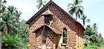
ST. JOHN’S MAROON CHURCH, FREETOWN (1956) The Maroons were the third group of original settlers in Freetown. The Preservation of this building in perpetuity has ensured that the term “Maroon” will not go into oblivion, as did “Maroon Town” for example.
ST CHARLES CHURCH AND REMAINS OF THE KING’S YARD WALL (1959) REGENT It was Rev. W. A. B. Johnson the first C. M. S. Missionary sent to that part of Sierra Leone that was very instrumental in converting the re-captives to Christian men and women. He witnessed the completion of the edifice in 1816, and throughout his service to the people, he saw the congregation grow from nine to several hundreds. He was regarded as the “Apostle of Regent” He died in 1823. St. Charles Church was named after Lt. Col. Sir Charles Marcarthy a Roman Catholic who became Governor of the Sierra Leone Settlement in 1814. He was much interested in the villagers, and followed the growth of Christianity among them. He was impressed by the spiritual devotion of the villagers, and so gave a lot of support to Rev. W. A. B. Johnson and the congregation. It was in recognition and appreciation of his work and support for the church at Regent that the church was named after him. Since, 1816 the church has undergone several renovations and minor extension. The first was in 1821 when the church was extended westwards and a gallery added to it. In 1913 Rev. N. H. Boston initiated renovation work, in preparation for the Centenary celebration of the church. The third renovation work was done in 1932 during the incumbency of Canon A. E. Williams. The slate roof of the church was completely removed and replaced by C. I. Sheets. Major extension was done to the Vicar’s Vestry in 1956, converting it to an organ chamber to accommodate part of the church pipe organ, which was the largest pipe organ in Sierra Leone. In February 1998, during the fight for the liberation of Freetown from the AFRC/RUF Rebels, the church was badly damaged. Through the effort of the parishioners and support of the diocese, the Sierra Leone Government, and other church as abroad, repairs were made to damages. Under the incumbency of Canon A. E. Nicol, the church was rededicated on the 28th June 1998. Since the birth of the church, twenty-four (24) vicars have served in it. The present Vicar, Rev. F. T. C. Randall is the twenty-fifth. (a) THE FIRING POINT AND FOUR GUNS NEAR THE OLD WHARF AT DUBLIN, BANANA ISLAND (b) TWO OLD TOMBSTONES IN THE CEMETERY AT DUBLIN, BANANA ISLAND (1956) There are two tombstones in the cemetery at Dublin. The first one is that of Captain Reid, R. N. and is dated 1712. This is the earliest tombstone found in Sierra Leone, older than any found on Bunce Island. The other is that of Lieutenant J. W. Roberts, R. N. dated 1847. VICTORIAN FIRE PLACE (1961)
THE MARTELLO TOWER, AT TOWER HILL NEAR THE HOUSE OF REPRESENTATIVES (1961) When the House of Representatives was to be built, there was talk of demolishing the Tower, but through the efforts of the late Dr. M. C. F. Easmon, the Tower was preserved and proclaimed a National Monument. It was cleverly incorporated into the design of the beautiful new Parliament Buildings.
THE OLD MILITARY BUTTS, (1962)
THE GRAVE OF CAPTAIN LENDY AT WAIIMA KONO DISTRICT (1965) By the time the mistake was realized, Captain Lendy on the British side and Lieutenant Maritz on the French side had been killed. Some other soldiers also died together with these two officers. Both Lendy and Maritz were buried on the spot and afterwards their brother officers erected a memorial cross, over them. In 1933 a new and larger memorial was erected incorporating the original cross. The Sierra Leone Government in memory of the soldiers who perished that day erected the new memorial.
REFERENCES Letters from the late Dr. M. C. F. Easmon For further details contact: Monument & Relics Commission |
 The Monuments and Relics Ordinance of 1 June 1947 provides for the Preservation of Ancient, Historical and Natural Monuments, Relics and other objects of Archaeological, Ethnographical, Historical or other scientific interest. The following is a list and brief History of the Proclaimed Monuments and Relics of Sierra Leone. The date of the declaration is shown in brackets.
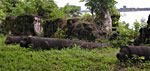 This Island played an important part in the early history of the Sierra Leone River, in the 17th and 18th centuries, especially before the formation of the Sierra Leone Company and the beginning of Sierra Leone, as we know it today. This island was successively a general trading factory gradually concentrating on the Slave Trade, became a definite slave depot, a timber warehouse, and a recruiting station for the British Army in West Africa.
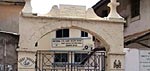 After the abolition of the Slave Trade in 1808, ships in the British Navy, which plied the Atlantic, were largely employed in the suppression of the Slave Traffic to the West Indies and the Americas. The captured vessels were brought to the nearest British possession (Sierra Leone) where a Vice-Admiralty Courts was set up in 1809 to deal with the legal aspects of the liberation of their living Cargoes, namely slaves, and the condemnation of the vessels. In 1891, parts of the duties of the Admiralty Courts were handed to the Court of Mixed Commission. The site of this court was where the General Post Office, now (SALPOST) stands. (A painting of this building, which was commissioned by The Monuments and Relics Commission before the building was demolished, now hangs in the Sierra Leone National Museum).